Parent Pages
Sibling Pages
Child Pages
Here is the City's draft traffic calming proposal from May 30, 2000. Please send your comments to Nancy Reynolds.
Contents:
�
Introduction
�
Bellevue Avenue
�
Fauquier Avenue
�
MacArthur Avenue
�
Crestwood Road
�
Stratford Drive
�
Appendix (Traffic Calming Techniques)
Bellevue Civic Association
Proposed Traffic Calming Enhancements
Welcome to Bellevue
Prepared by:
Department of Public Works
Division of Traffic Engineering
June 2000
This report is intended to provide a guide or roadmap for the Bellevue Civic Association regarding traffic calming enhancements. Traffic calming is the combination of mainly physical measures that reduce the negative effects of motor vehicle use, alter driver behavior, and improve conditions for non-motorized street users.
Traffic calming goals include:
� increasing the quality of life;
� incorporating the preferences and requirements of the people using the area (e.g., working, playing, residing) along the street(s), or at intersection(s);
� creating safe and attractive streets;
� helping to reduce the negative effects of motor vehicles on the environment (e.g., pollution, sprawl); and
� promoting pedestrian, cycle and transit use.
Traffic calming objectives include:
� achieving managed speeds for motor vehicles,
� reducing collision frequency and severity,
� increasing the safety and the perception of safety for non-motorized users of the street(s),
� reducing the need for police enforcement,
� enhancing the street environment (e.g., street scaping),
� encouraging water infiltration into the ground,
� increasing access for all modes of transportation, and
� reducing cut-through motor vehicle traffic.
The following streets were identified by residents in the Bellevue Civic Association for the Division of Traffic Engineering to recommend traffic calming enhancements:
Note: This is a draft version and once the residents have had ample time to provide input, direction,and achieve consensus, the Department will proceed in finalizing this report.
The following traffic calming enhancements will assist the Bellevue Civic Association in their attempt to better manage speeds on Bellevue Avenue.
Hermitage Road Gateway Treatment
 General
Observations
General
Observations
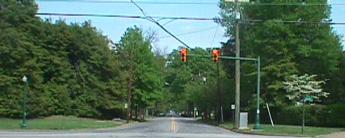
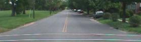
Traffic turning from Hermitage Road encounters a 36-foot cross section with very few parked cars until the motorist reaches Chevy Chase Street. The appearance provides for 18 foot travel lanes and a straight wide cross section. It is in this section that the motorist determines what speed to travel eastbound on Bellevue. Further, it appears that southbound to eastbound left turning traffic travels faster on Bellevue Avenue as these vehicles are trying to negotiate turning across northbound Hermitage traffic. Note: Sidewalks on the SE & SW quadrants of Bellevue & Hermitage should be continuous to the intersection with appropriate handicapped ramps.
Treatment
In order to prevent vehicles from speeding downstream, an effective solution will narrow the lane widths and still allow access through appropriate turning radii to emergency vehicle and GRTC busses. A median treatment that creates two 10 foot lanes and creates a 14� median would be effective solution. This island would start at a point dictated by critical vehicle turning radii and end just before the first set of driveways on Bellevue (approximately 100�-125�). This island would also be a prime location for landscaping and architecturally pleasing �Welcome to Bellevue� marker. Landscaping should not compromise the sight distance of westbound traffic with the signal at Bellevue & Hermitage. The signal indications and loop detectors may need to adjusted.
On Bellevue Avenue at Chevy Chase Street, intersection chokers should provide an effective means to insure managed speeds until the roundabout treatment at Bellevue & Fauquier. The opportunity exists for landscaping on the northside choker; however, only low lying landscaping should be provided on the southside for sight distance.
In summary, these two treatments in tandem will better manage speeds entering and exiting the neighborhood.
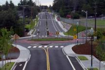
Roundabout Treatment on Bellevue at Fauquier.
General Observations
 This
intersection is the approximate geometric center of the neighborhood.
Both Bellevue Avenue and Fauquier Avenue provide necessary movements
through the neighborhood as well as access to properties adjacent to them.
Currently, unwarranted all-way stop signs control the intersection and
are creating unintended side effects that are contrary to basic traffic
engineering principles. A modern
roundabout treatment may more effectively managing speeds along Bellevue Avenue.
This
intersection is the approximate geometric center of the neighborhood.
Both Bellevue Avenue and Fauquier Avenue provide necessary movements
through the neighborhood as well as access to properties adjacent to them.
Currently, unwarranted all-way stop signs control the intersection and
are creating unintended side effects that are contrary to basic traffic
engineering principles. A modern
roundabout treatment may more effectively managing speeds along Bellevue Avenue.
Treatment
As Bellevue Avenue and Fauquier Avenue are approximately centered within the neighborhood, an appropriate enhancement would be to use a modern roundabout design to manage speeds. The center of this design should serve as a vista termination point. The design of this point should encourage the center of the circle to be occupied with a memorable structure that will anchor the intersecting streets for motorists and pedestrians alike and enhance this neighborhood�s character and sense of community. A vista termination point will aid the project as they serve to slow through traffic.
Both emergency vehicles and GRTC buses will need to be incorporated into the design through the use of special apron of different textured pavement. All four corner radii will need to be modified; particularly the NW quadrant as Fauquier north of Bellevue is too wide. In addition, deflection islands will be necessary on along all four approaches to slow travel speeds entering the roundabout.
Gateway Treatment on Bellevue just west of Brook Road
 Observations
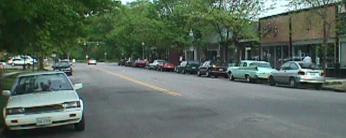
On Bellevue Avenue from Lamont Street to Brook Road, the cross section of this street expands from 36 feet to 46 feet and is bordered by commercial and parking uses. This area has a significant pedestrian use and the current parking lot located on the north side encourages uncontrolled midblock pedestrian movements. These pedestrians originate from on-street parking as well as from the parking lot. The eastbound movement appears to have two approach lanes from Lamont Street to Brook Road (385 feet) resulting in excess capacity for the observed traffic volumes.. This section is also a transition area from commercial use to residential use; yet there are no features to distinguish between the two uses.
Treatment
A pedestrian channelization feature such as a decorative fence (Approximately 120�) should be placed along the parking lot�s southern border with Bellevue Avenue. This would focus pedestrian movements to two locations: the intersection of Bellevue & Brook where pedestrian walk / don�t walk indications can safely guide pedestrians across and a mid-block crossing 135 feet west along Bellevue Avenue. This mid-block crossing should not be encouraged but will exist by default as long as the 35� driveway entrance to the parking lot is present. We would not want to openly encourage crossing at this point; but we will incorporate subtle design features to make this default crossing safer. A smaller parking lot driveway entrance design along with the decorative fence will slightly increase the capacity of the parking lot. Currently, the driveway is too wide at 35�. Standard two-way driveway entrances are 24� with 15� curb radii.
A gateway / channelization treatment on Bellevue just west of the parking lot driveway would be an effective enhancement. This treatment would better manage speeds entering the residential section from the east and further emphasize the pedestrian environment of the commercial section to vehicles entering from the west. This enhancement would provide a gateway to westbound vehicles and provide a channelized left turn lane for eastbound vehicles. By narrowing the travel lane width cross section from 30 feet to 20 feet, and still allowing access through appropriate turning radii for emergency vehicle and GRTC busses, this design will better manage speeds. A median treatment that creates two 10 foot lanes and creates a 10� median would be effective solution. This island would start at a point just west of the parking lot driveway and end approximately 75-100� to the west along Bellevue. This island would also be a prime location for landscaping and architecturally pleasing �Welcome to Bellevue� marker. Landscaping should not compromise the sight distance of eastbound traffic with the signal at Bellevue & Brook. Pedestrian movements will be enhanced at the default mid-block crossing as vehicles are better channelized and will result in reduced speeds.
Lane Narrowing Treatment on Fauquier
Observations
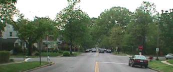
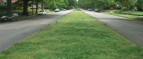
Fauquier Avenue possesses very wide lanes (27� in each direction) and is straight horizontally and vertically from Nottoway Avenue to its southern termini at Brook Road and Laburnum Avenue. In addition, there is a 10� grass median separating the two travelways with very little landscaping. All of these features in combination do not assist in controlling speeds on this residential street.
Treatment
There are several options to changing the perception of the driver travelling on Fauquier Avenue. One treatment would be to physically narrow the travel lanes from 27� to 18� and add 9� to each side of the median or to the face of curb. By narrowing the lanes, one creates friction and better controls travel speeds.
Another treatment would be to create a roundabout at the intersection of Claremont Avenue or Greycourt Avenue and Fauquier Avenue as it is in the center of this long corridor. By breaking the long stretch of wide pavement in half, one can control speeds more effectively.
One of the more cost effective treatments is to plant trees and other landscaping features in the median in combination with parking cars on both the median side and the curbside. Both of these items in combination will control travel speeds on Fauquier Avenue. The effective travel width would be reduced from 19� to 11� which is more appropriate for a residential neighborhood. In addition, the landscaping will provide a significant buffer between travel lanes and laterally narrow the width of the corridor.
Roundabout Treatment on MacArthur at Claremont
Observations
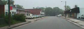
 MacArthur
Avenue at its intersection with Laburnum Avenue is 30� wide with 25� of
pavement. This cross section allows
for parking on one side of the street with two 11� travel lanes.
It was noted that sidewalks are not continuous and do not connect with
Laburnum Avenue. Its horizontal alignment is straight and transitions to a
36� cross section in the commercial area to the north between Nottoway Avenue
and Bellevue Avenue. This
transition allows for parking on both sides and two 10� travel lanes within
the commercial area. The wide open
look of the commercial area lends itself to speeding further south on MacArthur
Avenue. It is likely that most
speeders are associated with southbound traffic coming from the commercial area
and entering the residential section than the opposite.
MacArthur
Avenue at its intersection with Laburnum Avenue is 30� wide with 25� of
pavement. This cross section allows
for parking on one side of the street with two 11� travel lanes.
It was noted that sidewalks are not continuous and do not connect with
Laburnum Avenue. Its horizontal alignment is straight and transitions to a
36� cross section in the commercial area to the north between Nottoway Avenue
and Bellevue Avenue. This
transition allows for parking on both sides and two 10� travel lanes within
the commercial area. The wide open
look of the commercial area lends itself to speeding further south on MacArthur
Avenue. It is likely that most
speeders are associated with southbound traffic coming from the commercial area
and entering the residential section than the opposite.
Treatment
It is important to clarify for southbound drivers on MacArthur Avenue, the difference between the commercial area and the residential area. By narrowing the appearance of the commercial area and marking the completion of the transition to the residential area, traffic will hopefully pickup the visual cues.
 First,
by planting trees alongside MacArthur Avenue in the commercial area, the
appearance of the street will improve without removing any parking.
Second, by the introduction of a mini-roundabout or traffic circle at
MacArthur Avenue�s intersection with Claremont Avenue, a permanent marker
visible to the commercial area as well as traffic from Laburnum Avenue can
provide the key transition cue to the driver.
First,
by planting trees alongside MacArthur Avenue in the commercial area, the
appearance of the street will improve without removing any parking.
Second, by the introduction of a mini-roundabout or traffic circle at
MacArthur Avenue�s intersection with Claremont Avenue, a permanent marker
visible to the commercial area as well as traffic from Laburnum Avenue can
provide the key transition cue to the driver.
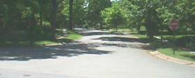
Parking Treatment on Westbrook Avenue at Crestwood
Observations
 It
appears that houses to the south of Westbrook Avenue would like to park on the
south curb of Westbrook Avenue. The
intersection crosswalks are well marked and sight distance is adequate.
Westbrook is currently marked as two 16� travel lanes and carries higher
volumes of interstate traffic. Crestwood
Road provides for parking on both sides and two 10� travel lanes.
It
appears that houses to the south of Westbrook Avenue would like to park on the
south curb of Westbrook Avenue. The
intersection crosswalks are well marked and sight distance is adequate.
Westbrook is currently marked as two 16� travel lanes and carries higher
volumes of interstate traffic. Crestwood
Road provides for parking on both sides and two 10� travel lanes.
Treatment
By restriping the current lane configuration on Westbrook Avenue to 18 feet from the south curb, one will be able to park on the street within 8 feet of the curb and allow traffic to travel on 10 feet. This reduction of lane width will help to control speeding from the interstate travelers headed in the eastbound direction as well as provide much needed parking. It will also provide a buffer zone between the travel lanes and residential use. Parking may need to be restricted around intersecting streets to provide for need sight distance. Westbound traffic will see a smaller travel lane from 16 feet to 14 feet.
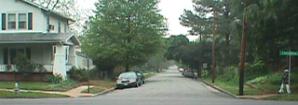
One Way Treatment on Pope Avenue at Crestwood
Observations
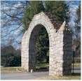
From conversations with the civic association, traffic continues to travel the wrong way on Pope Avenue which is one-way northbound. Pope Avenue is one-way due to a narrow historic gateway at its southern origin. Pope Avenue at Crestwood Road is very wide at the sidewalk (83 feet) and carries a 35� curb and gutter cross section.
Treatment
 Two
solutions are possible depending on which the neighborhood decides is the most
convenient. A treatment could be
placed at Pope Avenue and Crestwood Road with no access to Princeton Road or
placed at Pope Avenue and Princeton Road, with Pope Avenue becoming two-way from
Princeton Road to Crestwood Road. Extensive
island and median work would be necessary to geometrically insure that Pope
Avenue would function only as a one way street at Crestwood Road.
It would be easier to allow a small two way section and complete and
geometric changes on Pope Avenue at Princeton Road.
Two
solutions are possible depending on which the neighborhood decides is the most
convenient. A treatment could be
placed at Pope Avenue and Crestwood Road with no access to Princeton Road or
placed at Pope Avenue and Princeton Road, with Pope Avenue becoming two-way from
Princeton Road to Crestwood Road. Extensive
island and median work would be necessary to geometrically insure that Pope
Avenue would function only as a one way street at Crestwood Road.
It would be easier to allow a small two way section and complete and
geometric changes on Pope Avenue at Princeton Road.
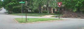
Redesign Treatment on Faquier Avenue at Crestwood
 Observations
The reason that very few motorist stop at this intersection when making a right turn from westbound Fauquier Avenue to northbound Crestwood Road are the long flowing curb radii. These allow for consistent speeds and are more appropriate for yielding conditions.
Treatment
These radii would have to be shortened and the intersection would have to be redesigned to have both intersections meet with at 90 degrees to effectively be stop controlled. A more likely solution, due to low volumes, is to change the stop sign to a yield condition.
Parking Treatment on Westbrook Avenue at Stratford Drive
Observations
It appears that houses to the south of Westbrook Avenue would like to park on the south curb of Westbrook Avenue. Sight distance is adequate and Westbrook carries heavier volumes of interstate traffic. Crestwood Road provides for parking on both sides and two 10� travel lanes. Westbrook is currently marked as two 16� travel lanes.
Treatment
By restriping the current lane configuration on Westbrook Avenue to 18 feet from the south curb, one will be able to park on the street within 8 feet of the curb and allow traffic to travel on 10 feet. This reduction of lane width will help to control speeding from the interstate travelers headed in the eastbound direction as well as provide much needed parking. It will also provide a buffer zone between the travel lanes and residential use. Parking may need to be restricted around intersecting streets to provide for need sight distance. Westbound traffic will see a smaller travel lane from 16 feet to 14 feet and result in very slight reductions in speed.
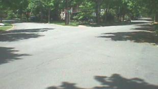
Redesign Treatment on Stratford Road at Newport Drive and Westminister Avenue
 Observations
This intersection is very wide and difficult to understand. It is wide open and very little channelization and conducive to increasing speeds to those that are familiar to this location. Long flowing curb radii and wide open stretch of asphalt are allowing for consistent speeds through the intersection and are more appropriate for yielding conditions.
Treatment
These radii
would have to be shortened and the intersection would have to be redesigned to
have both intersections meet with at 90 degrees to effectively be stop
controlled. The open spaces could
be filled with landscaped islands
Traffic Calming Measures -
Center
Island Narrowing
 Description:
� raised islands located along the centerline of a street that narrow the travel lanes at that location
� sometimes called midblock medians, median slow points, or median chokers
Applications:
� are often nicely landscaped to provide visual amenity and neighborhood identity
� can help pedestrianize streets by providing a mid-point refuge for pedestrians crossings
� sometimes used on wide streets to narrow travel lanes
� work well when combined with crosswalks
Potential Impacts:
� may reduce parking and driveway access
� reduces pedestrian crossing width
� may visually enhance the street through landscaping but may also limit visibility of pedestrian crossings
� bicyclists prefer not to have the travel way narrowed into path of motor vehicles
� collision, speed and volume data are not available
Emergency Response Issues:
� preferred by fire department/emergency response agencies to most other traffic calming measures
Typical Cost:
� reported costs range between $5,000 and $15,000 (1997 dollars)
Traffic
Calming Measures -
Pedestrian Safety Curb Extensions
 Description:
� curb extensions at midblock or intersection corners that narrow a street by extending the sidewalk or widening the planting strip
� can leave the cross section with two narrow lanes or with a single lane
� at midblock, sometimes called parallel chokers, angled chokers, twisted chokers, angle points, pinch points, or midblock narrowings
� at intersections, sometimes called neckdowns, bulbouts, knuckles, or corner bulges if marked as a crosswalk, they are also called safe crosses
Applications:
� local and collector streets
� pedestrian crossings
� main roads through small communities
� work well with textured crosswalks, curb radius reductions, and raised median islands
Design/Installation Issues:
� some applications use an island which allows drainage and bicyclists to continue between the choker and the original curb line
� typically designed to narrow road to 20 feet for two-way traffic; typically avoid the use of widths between 13 and 17 feet
� adequate drainage is a key consideration
� provides opportunity for landscaping
� vertical delineators, bollards or object markers are often used to make visible to snowplow operators
Potential Impacts:
� can impact parking and driveway access
� reduces pedestrian crossing width and increases visibility of pedestrian
� speeds have typically been reduced on average by 4 percent for two-lane chokers and 14 percent for one lane chokers
� minor decrease in traffic for two-lane and 20 percent reduction for one-lane chokers
� collision data not available
� bicyclists prefer not to have the travelway narrowed into path of motor vehicles
Emergency Response Issues:
� preferred by many fire department/emergency response agencies to most other traffic calming measures
Other/Special Considerations:
� one-lane chokers rely on regulatory signs and driver courtesy to work
Typical Cost:
�
approximately
$7,000 to $10,000 (1997 dollars)
 Traffic
Calming Measures -
Traffic
Calming Measures -
Modern Roundabout
DESCRIPTION:
Roundabouts are raised islands placed in an intersection. They are landscaped with ground cover and street trees. Roundabouts require drivers to slow to a speed that allows them to comfortably maneuver around them.
PURPOSE:
The primary benefit of roundabouts is they reduce the number of angle and turning collisions. An additional benefit is they slow high-speed traffic.
EFFECTIVENESS:
Roundabouts are very effective at lowering speeds in their immediate vicinity. Roundabouts are most effective when constructed in a series on a local service street.
|
Advantages |
Disadvantages |
|
Effectively reduce vehicle speeds Improve safety conditions (for example, there are fewer left-hand turn crashes involving other vehicles) Visually attractive |
Require some parking removal May cause bicycle/auto conflicts at intersections because of narrowed travel lane Can restrict emergency or transit vehicle movement if vehicles are parked illegally near the circle |
PARKING IMPACTS:
A minimum of 30 feet of curbside parking must be prohibited on the through street at each corner of the intersection.
TRANSIT SERVICE IMPACTS:
GRTC buses can maneuver around roundabouts at slow speeds provided vehicles are not illegally parked near the circles.
EMERGENCY SERVICES IMPACTS:
Fire trucks can maneuver around roundabouts at slow speeds provided vehicles are not illegally parked near the circles.
NOISE IMPACTS:
Noise impacts are minimal. There may be some noise related to vehicles decelerating and accelerating near the roundabouts.
OTHER CONSIDERATIONS:
If well-maintained, roundabouts can be very attractive. However, there are also a lot of traffic control signs and pavement markings associated with circles that are not so attractive.
Roundabouts are less effective at T-intersections and difficult to design for offset intersections.
COST:
Roundabouts cost approximately $5,000 to $15,000 each.
Last updated 02/24/02
Please send questions or comments to John Butcher