Parent Pages
Sibling Pages
Child Pages
The 1990 Census is available on the web from the Census Bureau. In particular, they have the census tract-level data for Richmond
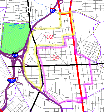
Our neighborhood is split along Bellevue Ave. between CT102 and CT 104:
(Please pardon the tract outlines. I am not an artist, and this is hard to do with a mouse.)
As you see, CT102 includes the northern half of Bellevue, along with the Seminary Ave. area north of Westminster Ave., and the neighborhoods on either side of Laburnum, west of the AP Hill monument. Imperial Plaza is in the tract. Part of the front lawn and parking lots of Westminster-Canterbury are in the area but the structures are in the County. The CT102 data appear to not include the Weistminster-Canterbury population. CT104 includes the southern half of Bellevue and Ginter Park south to Brookland Park Blvd., including the neighborhoods along Hawthorne and Noble Avenues. The Chamberlayne Ave. zoning disaster Runs through both census tracts and through these otherwise very nice neighborhoods.
We have downloaded a selection of census data on these two tracts and have analyzed part of the data.
Last updated 02/24/02
Please send questions or comments to John Butcher